
Friday, September 08, 2006
Stop the train, I want to get off
 Star-Bulletin reporter Crystal Kua dropped a bomb on Honolulu's yet unbuilt transit system today with her article Rail plan cuts $4B cost, routes. Her story demonstrated that plans for Mufi's light rail system are more pliable than viable.
Honest, I don't know whether to laugh or cry. It's not just the cost of construction of this ever-changing system that's of concern, but the damage and destruction it will do to people's homes and businesses. And if no one cares where it goes, then it's predictable that it may not go anywhere anyone wants. And think of the traffic congestion at the two end points.
It's unbelievable to me that where the train line will start and end will depend on how much money is on hand rather than what is needed to do the job. Enough said.
Transportation planning is not done on a whiteboard, easily erased on the mayor's next whim. Transportation is integrated into and inseperable from urban planning. Honolulu's urban planning seems non-existent. Developers lay claim to some land and either build houses that contribute to urban congestion and worsen traffic, or cave in when residents protest in order to defend their quality of life. That is not a plan, it's chaos.
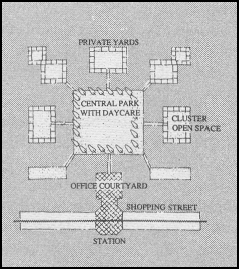
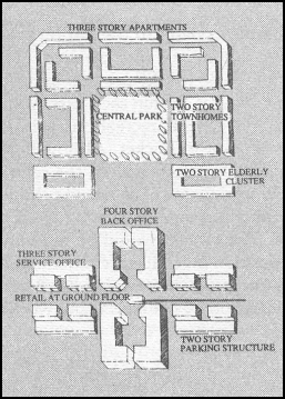
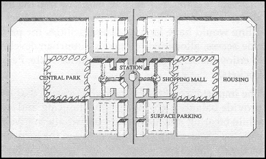
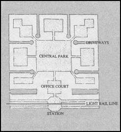 Here are two paragraphs from an article in the Spring 1988 Whole Earth Review by renowned architect and urban planner Peter Calthorpe. The article is titled Pedestrian Pockets. It's one version of an integrated planning model that every city has (with one exception, it seems). The illustrations in this post are snipped from the same article.
Regional Planning and the Pedestrian Pocket
Pedestrian Pockets are not meant to be stand-alone developments; they are intended to form a network of long-range growth within a region. They will vary considerably given the complexities of place and their varying internal makeup. Some may be larger than the 60-acre model we've been using as an example; the quarter-mile walking radius actually encloses 120 acres. Some may have a different focus; one providing a regional shopping center, one a cultural center, or a third simply housing and recreation. Some may be used to provide economic incentives in a depressed area as a redevelopment tool, others may rejuvenate an aging shopping area, others may be located in new areas zoned for low-density sprawl over a large area and serve to save much of the land from development.
But it is also important to use the Pockets and their rail line as a connector of the existing assets of an area. Certainly the major towns, office parks, shopping areas, and government facilities should be linked by the system. And several of the Pockets should offer an opportunity for park-and-ride so that existing housing in the region could take advantage of the line. Many new light rail systems which are built only to connect existing low-density development are experiencing some resistance from people not wanting to leave their cars. The importance of rezoning for a comfortable walking distance from house to station is to ease people out of their cars, to give them an alternative which is convenient and pleasing.
 An example from Japan
When we lived in a suburb of Tokyo ("suburb" is only a relative term in Japan, it was as dense as Waikiki), we walked ten minutes to the station. On the way one could grab some breakfast. There was bicycle parking near the station. Returning home in the evening I could shop for dinner, pick up my dry cleaning, some aspirins (for um, hangover), and even stop in a bookstore on the walk home. One station further was Kichijoji, with a park, a lake, and six (count 'em) large department stores and numerous eating places large and small, ancient and modern. One station the other way was medical care, the fish and vegetable market, office buildings, elderly housing, and so forth. Calthorpe would have recognized the design.
 Back to the Star-Bulletin article:
Originally, the route was proposed to be 23 miles long and run from west of Kapolei town to the University of Hawaii-Manoa campus with a possible spur to Waikiki.Well, no wonder. It would be hard to explain how the administrations' urban planning became such a shambles. Who would want to take a bus to get to a train, then switch to another bus to get to UH? Is this the transit system that is supposed to reduce traffic?
To save money, the start and the end of the route would change. Instead of beginning in Kapolei, the route would possibly start farther east at either the site of the proposed UH-West Oahu campus, which is just east of Kapolei town and along the future North-South Road, or at Leeward Community College.
The shortened route would end at downtown Honolulu, deleting the UH-Manoa and Waikiki ends.
Members of Mayor Mufi Hannemann's administration were not available to comment.
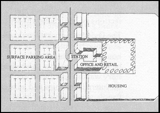 Calthorpe provides for those who need to drive their cars to the station (see the last illustration). He uses the same lot in multiple ways. But it only works if you can walk to your destination on the other side.
Tags:
![]()


Post a Comment